Geographic Information Systems (GIS)
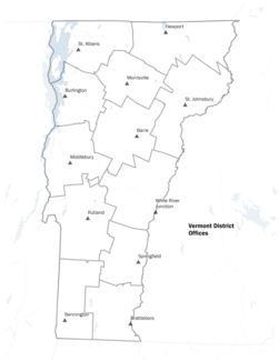
Geographic Information
Systems (GIS) technology involves using locational data to perform geographic
analyses and/or to create visual outputs such as maps.
For example, you can launch this Web map to view Health Department district office areas, health districts, hospitals, and hospital service areas. Or open on a handheld device.
Exploring Vermont Public Health GIS
- Public Health GIS
- Maps on Mobile Devices
- GIS Data Downloads
- GIS in Vermont State Government
- Contact Us
Public Health GIS
The Vermont Department of Health uses GIS technology to support a broad range of public health activities.
Health Surveillance
- Behavioral Risk Factor Surveillance System (BRFSS)
- Cancer Incidence Reports
- Health Disparities of Vermonters
- Healthcare Provider Reports
- Healthy Vermonters 2020
- Immunization
- Lyme Disease
Environmental Health
Public Health Preparedness
Health Promotion and Disease Prevention
Maternal Child Health
Local Health / Rural Health
Maps on Mobile Devices
The Health Department is responding to increasing demand for access to public health information that can be viewed using mobile devices, such as smart phones and tablet computers, by producing maps and reports that are tailored to mobile devices.
One example is our Blue-Green Algae Monitoring Reports which display differently for desktop computers and mobile devices.
GIS Data Downloads
Commonly used Vermont public health GIS data layers, formatted as shapefiles, can be downloaded as compressed .zip files using the links below.
Shapefiles can be loaded into a variety of GIS software and GIS Viewer applications. Additional Vermont GIS data is available from the state’s VGIS Data Warehouse.
*For a list of GIS software options, visit: http://en.wikipedia.org/wiki/List_of_GIS_software
GIS in Vermont State Government
GIS Technology is loosely coordinated across Vermont state government through the Enterprise GIS Consortium (EGC), which includes members from many different state agencies and departments
The Vermont Center for Geographic Information serves as the state’s GIS public non-profit organization.
Contact Us
Email comments and questions to: VDH-GIS@state.vt.us

